RIICE: Remote sensing-based information and insurance for crops in emerging economies

OBJECTIVE
- To reduce vulnerability of smallholder farmers engaged in rice production
NEWS
PROJECT DESCRIPTION
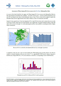
The tools of RIICE provide information about the scope and impact of disasters and a precise and timely overview of planted rice area and expected and actual yields – down to the village level. Such a national rice production monitoring system helps government decision makers, agricultural intermediaries, traders and relief organizations in better managing domestic rice production and distribution during normal growing conditions and after natural catastrophes struck. RIICE is further supporting its partners to use the generated information to implement agricultural insurance solutions that are more efficient and transparent.
PROJECT PARTNERS
Allianz Re, German Development Cooperation (GIZ), International Rice Research Institute (IRRI), Sarmap SA and Swiss Agency for Development and Cooperation (SDC) (funding organization)
PUBLICATIONS
- Improving food security through satellite technology
- Improving food security through satellite information
- REMOTE SENSING-BASED INFORMATION AND INSURANCE FOR CROPS IN EMERGING ECONOMIES
- RIICE REMOTE SENSING-BASED FLOOD ASSESSMENT HELPS GOVERNMENT OF TAMIL NADU, INDIA IN QUICKLY DIRECTING FLOOD RELIEF MEASURES
COUNTRY
Philippines
DURATION
Feb 2012 - Apr 2018